Tuesday, January 31, 2006

Cross country trip: Arches National Park in Utah


Inside Arches National Park the scenery speaks for itself. Apparently a lot of other people think that too. This park was crowded! Almost every parking spot was taken at each of the lots and several cars were making the rounds to snag the spaces that came available as tourists finished their perusal of a site. We got out of the truck to take a short hike around the north and south windows arches. It should be pretty evident if you go on a hike in the area to take water with you. It's desert, there is no water out there on the paths. There is very little shade too. The windows walk is a very easy one to do with small children. We'd have liked to hike out to the delicate arch, but we didn't plan on staying at the park long enough to undertake that hike and didn't think our 3-year-old would tolerate it without loud complaints.

If you go here you'll see signs at the beginning of most paths that ask you to stay on the designated trail only. The ground has a kind of shell, cryptobiotic soil, made of tiny living plants and animals that support the larger organisms out here, help hold the sand down during windstorms and do lots of other helpful things for the environment that I don't have time to fully explain here. One step onto this ground can destroy the shell for decades. Unfortunately, LOTS of visitors don't heed the signs reasoning that they are only one person so what harm could they alone do? If you get the chance to visit this park please don't be one of THOSE visitors!

There were so many places we wanted to explore here! The park offers tours through an area called the Fiery Furnace, a maze of winding tunnels and tight spots that requires a special use permit to enter. There are several arches throughout the park. Some are visible from the main road but most require a trip down a side road and then a hike of varying lengths and efforts. There is also a campground at the end of the main road in the park in the Devils Garden area. If you intend to stay at the campground contact the park before your arrival. I believe they go through a national reservation center instead of keeping their own reservation system. It was full while we were there and seems busy most of the time.
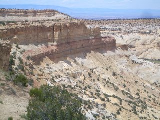
After a quick look through the campground we were ready to get back to the highway. The northern end of Arches National Park doesn't seem to far from I-70 and we wondered if there was a way to get back there without backtracking through the park back toward Moab. We had noticed a gravel road that left the main paved road in Arches toward the west. I was really hesitant to take it: We weren't in a 4x4, this was the desert in June, we didn't have a whole lot of provisions in case something happened, and no one knew that we were thinking of going that way. Under those circumstances I'd council anyone who asked me NOT to temp fate. My husband is more adventurous than I am though. He used a "toe in the water" technique to ease me down the road. First he just wanted to get a picture of the truck down a desert road in the middle of nowhere and we could go back as soon as he'd done that. Then, since we were down there why not drive a little further and see where it went. We continued down the road, him with a grin on his face because he had his way and me trying not to appear sulky because I had not. After a few minutes he asked what was wrong. I said the typical "nothing." I didn't want to ruin this for him especially after his disappointment back in CO trying to go through Rocky Mountain NP but I was scared out of my mind! What on earth were we doing leaving the comfort and familiarity of the paved road to try out this unknown desert road that had no signs to affirm that it lead anywhere. Sure, as far as we could see it headed in the direction that we wanted to go--but what about what we couldn't see? Well 10 minutes later or so we saw a dust cloud moving in our direction. It was a truck with a local couple inside and we were able to flag them down to ask them about the road. Turns out it does leave the park and connects with route 191. They gave us the sort of country directions that only locals can follow: go about 4 miles past the hollow and hang a left at the old railroad crossing, go another 2 miles to the cowpen and then take a right onto such and such gravel road and then your only 5 miles from the highway and it's a straight shot. We thanked them for the directions and Ron felt vindicated that he had made the right choice. I felt easier knowing that this way would work if we could make heads or tails out of the directions that we were given. And on we went. We did pretty well up to the 'hollow' part but from there we couldn't remember anything of the directions. We just followed the road in the general direction making turns that seemed to bring us to the northwest. We did find our way out of the national park so if you are looking for a back entrance, YES, there is one. NO, it has no gate. However, it is a pisser to find! If you use it without paying you are trespassing and if caught at best will be asked to pay the entrance fee and at worst... whats the penalty for trespassing on government property?

We never made it to route 191 and we got really nervous a few time on the dirt road. there were a couple of places where there were sheer drops on either side of the road. Lots of animals out there too. We had quite a few deer stand in the middle of the road we were attempting to go down. After a while we could see 191 running to the west of us about 4 or 5 miles away but we couldn't find any approach road to get there. Eventually we found ourselves at an entrance right onto I-70 itself just a few miles east of where it intersects route 191. That was a relief!!! (I've never seen so many dirt roads as in Utah. Quite a few of the interstate exits lead directly to dirt roads.) Back on the main road we headed west again and didn't stop until we reached Richfield, UT except for a picture here and there at scenic overlooks.

I'll leave you with some more pictures from Arches National Park and along I-70.


Delicate Arch seen from the trail at the viewing point past Wolfe Ranch.


Near the Fiery Furnace area.


A view near the Capitol Reef National Park and Fishlake National Forest

Monday, January 30, 2006

Cross country trip: Into Utah

Every evening of our trip we unloaded the truckbed into our hotel room and then in the morning we'd reload the truckbed. We have a nice bed cover, but since the items were important enough to carry on the cross-country trip with us I wasn't going to let them be left in the truckbed where sticky fingers might get a hold of them while we weren't watching. This morning was no exception. We drained the water from the cooler and loaded our possessions back into the bed. Got the children comfortable in their carseats and set out on I-70 again. We greeted the Colorado River a few more time in the 15 of our drive before it turned off toward the south. From Grand Junction, we stayed on the highway just about an hour before finding our first detour. We wanted to go to Arches National Park, but we didn't want to do any backtracking along the same roads if we could avoid it. Both of us feel that if we have to back-track we have wasted our time. We'd studied the map the night before and the only major route to Moab from I-70 that we could find was Rte 191 so we looked for a minor one instead. Exit 202 to route 128 is pretty obscure. You could easily miss it if you aren't paying attention. Try not to though! The road takes off through the desert almost due east about 2 miles before turning toward the south. It goes past a few widely spaced ranches and has some great views of Mt Tomasaki. About four miles after turning south the road connects with the Colorado River inside a canyon cut through some really pretty redrock. (I wish I could give you more geologic info about this!) We saw something interesting around every bend and stopped to take picture almost as often. Of the entire road trip, this portion was my favorite! I was a bit towrn about whether to write of this road or not. It doesn't appear too promising if you look at a road map. It's a two lane, narrow, winding minor road but it was my favorite part of the whole road trip. It wasn't very busy either. I hope that it continues to have light traffic. We followed the road down to Moab, stopping at ocassional recreation areas to watch a few rafts go by, take some picture, admire the beauty, or skip some rocks across the water. In Moab we stopped for some beef jerky snacks and to talk to some locals at a bike shop. My husband used to ride the midwestern mountain bike race circuit in his late teens and lots of the teammates talked of riding the slickrock in Moab.(Moab is something of a Mecca for serious mountain bikers.) It's been years since he's done any competitive riding, but he still likes hearing about what's going on in the sport. He gathered the info he was looking for, mentioned that he'd like to come back some time, and then got back in the truck to continue our trip. The next stop: Arches National Park. I'll write about this one in a day or so. I'll leave you with a few more pictures from along route 128. My kids in front of a large rock formation; everyone trying to skip rocks across the river; and my son finding a large rock that he wanted to skip.

Friday, January 27, 2006

Cross country Intermission for Tolkien quiz

Before we head into the Utah portion of this trip I want to share this with you. I was browsing through blogs and found a link to this quiz site. Thought I'd try it and this was my result. Why don't you give it a try?

Entish
Entish


To which race of Middle Earth do you belong?
brought to you by Quizilla

The blog that I got it from was http://mixmoss.blogspot.com/ After you get done with the quiz, take a look at the blog! Then come back and read more of mine. Take care!

Cross country trip: Aspen to Grand Junction


Traveling route 82 from the south east to Aspen, CO is a pretty cool trip. I mentioned in my last post that the road has some harrowing features to it, but it's full of interesting scenery too. I loved watching the environmental changes as we decended from Independence Pass toward the famous ski town. We watched as the scene outside the window changed from lots of snow and no trees in sight, to evergreens on both sides. A few times we would round a corner and see a patchwork below us of pale green interspersed within deep evergreen; the Aspens that gave the area it's name. Route 82 comes right into Aspen, CO on Cooper Ave, turns to the right for about 3 blocks on Galena and then turns back left on Main St. Even in early June, after the ski season has ended, this town was full of activity. Street parking was difficult to find, but worth the effort. I don't enjoy shopping much, but I could see that Aspen offers LOTS of shopping from inexpensive T-shirt stores up to very high end boutiques. We walked the streets for a few minutes and then headed over to the resort. The gondola to the top of the mountain was still running for the day, taking tourists like us up to enjoy the view of the surrounding mountains andthe town. They offered several outdoor activities at the top as well, and there were still a few inches of snow up there, which my kids were immediately drawn to once we made it up.

We had a hard time convincing our son to get in the gondola. He thought it was an airplane and the whole idea of it frightened him. I had to carry him on and he wouldn't sit anywhere other than my lap for the whole ride. He sat there with the most serious look on his face for the entire trip up the mountain. We didn't spend a lot of time at the top. Just enough to look around, take some pictures and head back down. We were going to have lunch up there, but the lodge was closed to get ready for a reception later that evening.

Back at the bottom, we stopped in at a restaurant on a street corner. Actually, a store was on the street corner. To get to the restaurant you had to enter the store and go up the stairs. I don't remember the name of the place (that's the hazard of not writing your memoir until 6 months after it takes place!!) but it had a nice balcony seating area with a view of the rest of the street below and it served delicious hamburgers. After lunch we were ready to get on with the trip except for one small errand. My husband had a beer called "Fat Tire" with lunch. He thought it was very good microbrew and since he hadn't seen it before he wanted to get some to take with us. A quick trip to a minimart secured that purchase and we were on our way. He was pretty excited about his new find too. He thought it was just a local brand, but we'd later find that it was pretty common at least from CO westward.

We left Aspen and continued on route 82 back toward I-70. There was a lot more traffic than we expected along the way. This part of the drive was ok, but there wasn't anything in particular that drew my attention until we got back to I-70. From Glenwood Springs on west almost to the Utah line, I-70 follows the Colorado River. The road leaves the river occasionally, but never for very long. We saw several kayakers and white water rafts along the way, which made us wish again that we had more time and a babysitter. The snow-topped mountains and thick evergreens gave way to more redrock and a desert-like appearance the closer we got to Grand Junction, CO. I guess we were entering the Great Basin. In Grand Junction itself, the thing that caught our eye was an A6-Intruder monument. This was the plane that my husband began his naval career working on and he had to have a picture of it. Both of us wondered why the monument was here, but we didn't have the time to look for the answer. We wanted to get to the hotel and get some sleep before the next days trip in Utah.

Monday, January 23, 2006

Cross country trip: Colorado day 2

We began the morning with an attempt on the summit of Mt. Evans which I described in my previous entry. Like our experience with Rocky Mountain NP; it didn't happen! Instead we decided to explore a little south of I-70. My husband has talked about Leadville, CO for as long as I can remember. This part of the story requires a little background: my husband has always been fascinated with maps. Back in high school he saw the town of Leadville, CO on a map and swore that he was going to live there some day. Until this trip, he had never seen the town or read anything about it except for it's location on the map. Now that we were in Colorado he was definitely going to visit Leadville! We didn't have a definite plan for today except Leadville. We weren't expecting to make it very far... only to Grand Junction because we wanted to make the next days trip to Moab during daylight.

We took a little detour off I-70 to avoid the tunnel and head over Loveland Pass. Then we got back on the interstate for a few minutes and exited on route 91. We just spent the time looking out the windows and talking about what we expected Leadville to be like. We stopped for pictures here and there. Caught some skiers leaving fresh tracks in the snow. Talked about how nice it would be out there skiing ourselves. (He's the skier, I'd end up sliding down on my rear if I was lucky.) Then drove on until the nest pretty site caught our eye. It didn't take too long to get to Leadville. We pulled into town just in time for a much needed restroom break. We stopped at the first restaurant we saw, I think it was a Hardees but I'm not completely sure. I do remember that there wasn't much to choose from. Everything in Leadville seemed a little run down. It seemed as if time were passing the town by. It still has the feel of an old western mining town. (Or at least what this eastern-born girl imagines one would feel like.) A short way down the street my husband announced that he didn't think he would live here after all.

Another thing that we both like to do is Whitewater Rafting. We've rafted the Gauley River in West Virginia together once and he's gone a few times on his own. We often sit together and research and plan rafting trips and one of our favorite places to dream of rafting is the Arkansas River. Before we started our road trip Ron had found that quite a few of the Colorado Whitewater Rafting companies had headquarters in Buena Vista, CO. Leadville is only 42 minutes from Buena Vista... there was no way we could get that close and not head down there! So we continued our meanderings through Colorado down state route 24 past the ivy league mountains. I was struck by how much the scenery changed on the way down there. Buena Vista's valley is much more desert-like than the area we had just come from. There was red rock all over the place and it was much warmer than back in Idaho Springs. When we got close to the town we found several rafting companies. Both of us were itching to take a trip down the river. If we could have found a reliable babysitter on short notice we'd have been on the next raft! Instead, we had to settle on a view of the river from the shore. While we stood there watching a couple of rafts passed into a nice set of rapids in front of us. We just stood there wishing we were out there with them. I think we could have stayed all day watching them, but the kids were ready to move on.

We wanted to get on with our trip without too much backtracking, so instead of going north back through Leadville we decided to try route 82 to get back to the highway. I was a bit worried to be taking a low priority state road, especially considering our previous track record with the roads through the Colorado high lands. We decided to take our chances though and we made it through ok. This road goes through San Isabel and Gunnison National Forests and skirts the edge of the Hunter Fryingpan Wilderness. There are several opportunities for outdoor recreation along the way. There are a couple of scary sections on this road though. The first ones we encountered were between Buena Vista and Aspen. A couple of times this road goes down to one lane because of large rock overhangs on the side of the mountain. The edge is very steep in most places and when it goes to one lane, most of the time you can't see what is coming toward you. I have no idea if the road is very busy usually, but luckily for us it wasn't that day. Once again, I sat there clutching those oh-sh** handles! It seems like a long section of road between Buena Vista and Aspen, and it's a relatively slow going, but there is beautiful scenery! At the top of Independence Pass, all of us felt a little breathless.

Saturday, January 21, 2006

Cross country trip: The end of our first day in Colorado

After we accomplished as much of of our original goal (driving through Rocky Mountain National Park) as possible, we turned back south the same we we had just driven to head back to I-70. It was already pretty clear to us that the plan to get to Grand Junction before dark was pretty well shot. Plus my husband still wanted to see more of the Colorado high country before we headed to the Great Basin and beyond. He had remembered seeing a sign about the highest road in the US back in Idaho Springs. Maybe we'd have a chance to make it to the summit of that mountain since instead. So when we got back to the interstate instead of continuing west, we went back east a few miles. We got off in Idaho Springs again and set off for Mount Evans but no sooner had we turned onto the road than I spotted a sign that said the summit road was closed. I suppose I could have kept my mouth shut about seeing the sign, but I was pretty tired by this time, hungry too. I said "Hey, I think I saw a sign that the road is closed." Ron seemed like he didn't hear me, but I noticed his jaw was set very firmly. We continued following the road another seven miles or so before he sighed and asked if I was SURE I'd seen the sign. "Yes, I was sure." We turned around and headed back toward the town and the visitor center. The visitor center was also closed by this time so there was no use stopping to ask questions. We sat in the parking lot a few minutes to figure out again what we wanted to do. It was getting pretty late by this time so we decided to stay the night in Idaho Springs and attempt Mount Evans in the morning. We hoped the road was just closed for the evening and not for snow up at the summit.

I wish I could remember the name of the hotel we stayed at in Idaho Springs. It was the largest room of any of the hotels we stayed at during our entire trip. All that I remember was that it was on the east side of the town, and on the north side of the main street. It seemed to be an older hotel and it was mostly one story, white and fairly spread out compared to most motels. It's a shame I can't remember it because I'd recommend it to travelers passing through who want to stay at a nice, relatively low cost place. We did some laundry here, mostly because we wanted to wash the car seat cover after the incident earlier in the day at Estes Park. Then the kids and I relaxed for the evening with a TV movie and some pizza. Ron was having difficulty relaxing since none of his plans had gone the way he wanted that day. He decided to walk down to the nearest bar he could find for a beer.

The next morning we headed for Mount Evans. We sat in the visitor center parking lot for a couple of minutes trying to find out if the road would open. The center, unfortunately, wasn't open but Ron managed to track down someone who told him that the road was open at least as far as Echo Lake and that it was worth the drive to go here even if the rest was closed. We took their advice and drove on up. A little before the lake we noticed the wind pick up considerably. The view was beautiful, but the wind was unbearable in the clothes that we had available to us. We stopped on the side of the road while Ron jumped out to take some quick pictures. Then we drove a bit further until we came to a restaurant, a barrier gate in the roadway, and a parking lot full of cars with trailer. There were also several park ranger trucks and a large mobile command bus. I was curious to know what was going on so I hopped out and asked. Some hikers had been reported missing the day before and everyone up there was involved in the search for them. While I was gathering the information Ron got the kids out of the car and herded them over to the restaurant. Inside we got more news that the summit road was indeed closed. They expected it to open later in the day. Could be in minutes, could be in hours. We decided to wait an hour or so and have some breakfast. The restaurant at Echo Lake does a tasty homestyle breakfast and the staff up there were very helpful and nice. We sat near some of the search crew who were also eating breakfast. Just before we got up to leave I overheard on their radio that the hikers were found alive and well and were being brought to base camp. That was nice news to hear! Our kids picked out a couple of souveniers before we headed back to the truck. The summit road was still closed and the place was getting more and more crowded as news of the hikers made it's way to the search crew members. We turned around again and headed back to the highway.

Tuesday, January 17, 2006

Cross country trip- animals & people in Rocky Mountain NP

On the western side of Rocky Mountain National Park, we drove through the Grand Lake entrance. The ranger her confirmed that the road was still impassable from Milner Pass to Rainbow Curve. Shortly past the gate we were rewarded with the view of several elk in a field, and one that was standing in the road blocking our path up the mountain. This wasn't too big of a deal. We had no problem sitting in the truck and watching as it took it's time crossing the road. As is often our luck, we weren't able to get the camera out quickly enough to catch a better view of the gorgeous animal... only the tail end. Time and again we caught glimpses of the elk. Here are several more pictures. Only once did we get a frontal portrait. Everyone in the truck was happier now and the conversation was flowing much easier because we were going to see most of the park after all. Sure, we were still going to miss the Alpine sections, but at this point we were grateful to have been on both the eastern and western sides of the park! We continued following the road as far as we could. There was very little snow. Nothing at the bottom and not much up high either. At a turn out, we took a picture of the valley we had just traveled through. We tried to figure out which river we were looking at, but didn't have a map with its name on it. I'm sure that someone will supply me with the name, but for now I'm just going to say it was a tributary of the Colorado river, if not that river itself. I'll place another post with the rest of the photos for this section in a minute. (The blogger doesn't seem to want to add any more here. When we got out of the car to take the picture we had a cute little friend who was doing a little more than begging for food. What looked like a chipmunk popped out of the trash can and ran along the stone wall to where we were standing. It then tried to climb into my husband's pocket to look for food. The kids were charmed and wanted to pet it and take it with us. I was busy trying to get the kids back into the car away from the animal. I don't want to encourage my kids to befriend wild animals. It was obvious that this animal had met with people that don't follow that philosophy. I think it is selfish, cruel and dangerous to pet or try to hand feed wild animals. There are extremely few exceptions to this rule and never any exceptions within a National Park. I have a few stories from my park ranger days of what happens when animals and people get too cozy. I'll share them later.
After our close animal encounter, we continued the drive up to Milner Pass. We stopped up there and the kids played in the snow. We took a picture of them in front of the continental divide sign and we talked with a couple of people who noticed our Virginia license plates and stopped to talk. They had lived in Virginia before moving to Colorado and were always interested in talking to people from there. We told them about our military transfer to California and our cross-country drive. They thanked my husband for his service, shook his hand and headed their own way.

Friday, January 13, 2006

Cross country trip continues through Colorado

I think when I left off, we had just arrived at I-70 again after our disappointing attempt to cross Rocky Mountain National Park by road shortly following an early summer snowstorm. We still had a lot of daylight hours left and a resolve to see as much of the park that we had driven so far to see as possible. As we drove past the little town of Idaho Springs, my husband made up his mind to attempt the park from the western side at the Grand Lake entrance. I don't think he really expected to go all the way through considering what we had heard earlier in the day. (The road was only closed from Rainbow Curve to Milner Pass, that's only about 10 miles of road.)

We turned off of I-70 just a few minutes after we go on it and headed up Rte 40. I'm glad we got the chance to take this extra side trip, even if it didn't happen quite the way we'd envisioned. We drove through the town of Empire, CO and I don't remember much about it except that it was a little before Berthoud Pass (our first introduction to Rocky Mountain passes.) The closer we got to the pass, the worse the weather got. Ice and snow and wind made me very nervous. As a southern girl, I'm used to flat land that receives snow maybe once a year or so. I was pretty jumpy everytime we went around a curve or passed another car and my knuckles got progressively paler with the climbing altitude and my tightening grip on the 'oh sh--' handles. When we stopped at the Berthoud Pass parking lot overlook I was extremely thankful that the park rangers had closed the pass to vehicle traffic! There wasn't as much snow as I thought there would be, but it was enough to let the kids out for a minute to play before continuing. I'd like to tell you that the view was spectacular with stunning Colorado mountain vistas, but there was no view at all due to the snow and low-hanging clouds.

We left Berthoud Pass and continued north through Winter Park. I had never been here before, but my husband had taken a ski trip here when he was in high school. We could see that most of the snow on the slopes had melted, but we pulled into the parking lot and he pointed out a few of his favorite runs to me. We also stopped at a gas station to pick up the a few items to snack on for lunch. Then we continued on north. Everytime we came to a new town I remember saying that I'd love to live there. Each little town seemed to have so much charm! We didn't stop again though until we got to the Grand Lake Entrance.

I'm sorry to cut this short again. My daughter just got home from school and wants to 'do something.' I'm going to have to go and make sure that I approve of whatever the 'something' is. I promise that we will make it out of Colorado sometime in the next few days... Come to think of it, Colorado is not a bad place to be 'stuck'!

Wednesday, January 11, 2006

Cross-country trip Part III: Rocky Mountain National Park

After cleaning up the back seat from my son's bout with car-sickness, we got back on the road and made it to the Fall River entrance of Rocky Mountain National Park. The weather had seemed to clear up fairly well where we were, BUT... the ranger at the gate said that the through road was closed due to blowing snow. Now, if you've read any of my previous posts, or even the title of my blog hopefully you've realized that I have nothing but the highest respect for park rangers. One look at my husband's face though and I was ready to seek out the snow removal equipment and head up to the pass myself! It wouldn't have done much good: the problem wasn't large amounts of snow on the road so much as blowing snow... high winds... zero visibility... steep slopes and low guard rails; but I'd sooner face all those things than disappointment in my husband or children's eyes! We asked when they expected the road to open thinking that maybe we could stick around an extra day or so to complete this drive. The ranger said they were hoping it would open later in the day or the next day sometime. With that ambiguous answer, my husband bitterly said something about lazy park workers and other things that I didn't quite catch, but got a fairly good impression of. Then he sighed and asked how far we would be able to drive in from the gate. 11 miles was the answer. With another heavy sigh and my daughter repeatedly asking "what's wrong?", we headed into the park. The first couple of miles in everyone stayed pretty quiet, watching the scenery and hoping that daddy's mood would improve. Then my daughter saw some elk and wanted to stop and watch them for a few minutes. We stopped, watched and took some pictures and then drove on. At the end of 11 miles we came to an overlook with a restroom just before the road closed barrier. While we didn't accomplish our major goal, the view of the valley we had just drove through was impressive. Still, my husband was disappointed. When we got out of the car and looked around, the only snow immediately visible was to tiny patches hidden on the north sides of large rocks or trees. I heard him mutter "$*&! park ranger doesn't know what he's talking about! There's NO snow." To try out my newly learned psychology terms, I'd say he was definitely exhibiting denial and rationalization, with a bit of regression thrown in. (Thanks Mrs. Downing, I have now officially learned what you taught outside of the classroom!) We got back in the car and tried to decide what to do next. My husband's vote was to remove the barrier and continue on through the pass anyway... he was only half joking. We consulted the map and decided to head out of the park through the Beaver Meadows entrance and drive down Rte 7 to Rte 72 to Rte 119 through Blackhawk, CO, to Rte 6 and finally onto I-70. Maybe the locals know a better way to cross the Mountains north of I-70, but we couldn't find anything on our map that would work. The drive we took was an interesting one. Lots of tiny towns and large ranch estates. I was amazed by the town of Blackhawk! I definitely want to go back and explore further!

Well, I thought I was going to have time to get a little further in my tale, but the rest of my life is calling me right now. I must go take care of it.

Cross country Intermission

Ok, after a stressful day on the road one of my favorite things to do is shop! I can't always head out to the mall though, but I can always bring the mall to me at www.youronestopstore.com/11022

Sometimes a different kind of diversion is called for... www.mycasinosonline.com/11022 offers a fun and exciting way to pass the time. They'll also match up to $200 of new accounts. Check them out!

And my husband's favorite is www.premiershoppingsite.com/11022 He heads there everytime he is looking for rare CD's to add to his music collection. They have so much more than music though!

Take the time to check these sites out for world-class shopping and entertainment in the comfort of your home.

Tuesday, January 10, 2006

Cross-country trip Part II: The journey continues

Ok, I left off yesterday in Cheyenne, WY. I still smile when I think about this town. It may be a place I'd like to live in the future... When the government doesn't decide the area of the country my family is obliged to reside in. We enjoyed the (relatively) small town atmosphere that this city offers and were delighted that everyone we talked with was so friendly. We only spent a short time here, but everything we saw and everyone we met did the city a great service!

Except for widespread thunderstorms on our drive through Iowa, Nebraska and Wyoming the weather had largely cooperated with our cross-country trip. This was about to change however. As soon as we crossed the Wyoming/ Colorado line on I-25, we seemed to go through a curtain of clouds. Almost as if there was an atmospheric gateway that coincided with the arbitrary stateline. The veil of clouds hung over us all day long, blocking what I am told is a magnificent view of the Rocky Mountains from the Colorado frontrange. What a shame for us! This was the part of the trip that my husband had been most looking forward too! He had spent hours pouring over maps of Colorado planning everything that he wanted to see and all the places he wanted to explore. Months earlier he had purchased an annual National Parks pass mostly in anticipation of our cross-country tour. As each mile passed in Colorado I could see and feel his excitement deflating. At the start of the morning he kept saying "Wait until you see those Rocky Mountains!" Then as we drove on he said "Maybe it will clear up in time to drive through the park." We stopped in Loveland for a late breakfast at one of those diners that serve breakfast all day long. Through breakfast I heard him say "Why does this always happen to me? Why is it everytime I want to do something it gets ruined?"

When we left the diner, the drizzle had stopped and the sun seemed to want to break through the low lying clouds... but it wasn't very successful. We headed straight west from here on SR 34. My husband was still lamenting about his dashed dreams, while I tried to reassure him that there was still plenty of time for conditions to improve enough to travel through Rocky Mountain National Park. In fact, I said "I bet it's sunny and clear in the next valley over." As we drove west, the clouds did dissipate and we saw more and more of the sun, though the wind picked up a bit. We drove through a beautiful canyon area on SR-34. I'm not sure if this road is a well kept secret, or if I was ignorant of its existence because up to this point in my life I hadn't really spent any time further west than around the Mississippi River. We enjoyed the twists of this road around the canyon walls, and were charmed by the river at the bottom. The combination of a change of scenery and road more challenging than the Interstate system boosted my husband's spirits a bit. The sky continued to be colored grey throughout the drive, but the grayness lightened and brightened considerably. And on the other side of the mountain was one of the nicest cities I've ever had the privilege to visit. Estes Park is a gem hidden in the Rocky Mountains. As the gateway to Rocky Mountain National Park, it does get hundreds of thousands of visitors each year, but when we drove into the city, I felt as if I was discovering a hidden city that the rest of the world knew nothing about. While my husband, my daughter and I were busy taking in all the sights as we drove through, my son's head, and stomach, were swimming with all the rapid change of scenery... and possibly the greasy breakfast he had eaten earlier in Loveland. He was fighting a battle with car sickness, and lost it about 3 seconds after saying "Mommy I don't feel good." Three seconds is NOT enough time for that statement to sink in fast enough to find a safe place to stop and get a three-year old out of a 5-point harness carseat. He quickly brought our attention back from our surroundings to the immediate situation inside the car. We quickly pulled into the parking lot of a local hotel and I jumped out of the car to attend to my son. When he gets sick, his inclination is to tilt his head back instead of forward to avoid getting any on his clothes, and I was afraid that he might choke on what his body was trying to get rid of. After a couple moments of confusion and tears, we got him squared enough to continue the trip until we reached the the town which we had pre-chosen to stay the night. I knew there was a reason that we brought Lysol disinfectant wipes in addition to the regular baby wipes and extra changes of clothes! Thank you Lysol for keeping our long trip smelling nice and lemony instead of the alternative! And no, I don't have an endorsement for writing that (yet... :-).

Well, I still haven't actually gotten to the part about Rocky Mountain National Park. Once again, I'll beg off and attempt to write that tomorrow. My son has just gotten out of bed and now I must begin the rest of my daily activities. Stay tuned!

Monday, January 09, 2006

Cross-country trip

Ok, here's my synopsis of the family cross-country trip. I should have written this a long time ago! We set out from Virginia at about 6am on June 4th 05. With 2 kids, I insisted on not traveling more than 8 hours each day. Since we were driving 2 cars to start, I ended up having two blissfully quiet days... Just me and the cat in the car. The kids rode with my husband. Thanks to portable DVD players, he had a pretty quiet trip too. I think I remember him humming a Disney theme song once during a lunch stop though. (Quite humorous considering his idea of great music is Iron Maiden and Opeth.)

We stopped for the evening in Ohio, halfway between Virginia Beach, VA and Dubuque, IA. It was a pretty uneventful night. There was a big thunderstorm, that's about it though. In the morning we got up early and drove to Dubuque to spend time with my in-laws before continuing our trip. Basically the first two days were uneventful and kind of boring. We were in such a hurry to get to Iowa that we didn't have time to take in any of the beautiful scenery that West Virginia has to offer. We've never taken much time to explore Ohio or Indiana, or Illinois either and this trip was no exception.

We had a lovely visit with my in-laws. We got the chance to see everyone we wanted to see, but didn't stay long enough to start feeling antsy. We enjoyed showing our kids the farm that my husband and his father grew up on. One of the days there we watched as the baler drove around the field eating up the lines of hay laid out in rows and stopping occasionally to regurgitate a huge round bale. Every time it did, my daughter would make the appropriate sound effects to go along with the regurgitation idea. She though it was great fun! My son, who is so interested in cars, trucks, and big tractors, was terrified of the tractor and baler. Everytime it came close, he would run and hide behind the house. If I went to bring him out, he'd be tremble and say "no, let's go watch Scooby-Doo."

We got to go camping at the pond while we were there. The kids loved that. They did a little fishing, a little playing in the mud and a little bit of paddleboating. They had fun with their cousin and with the neighbor's kids too. There grandfather built a campfire that he was quite proud of! He built a little concoction of household materials that caused the fire to glow blue and green in addition to the normal orange-yellow of campfires. The kids were amazed at his ingenuity! Over and over again we heard that it was the best campfire in the world and that probably nobody else had a campfire as nice as this one.

In town, we spent time with my mother-in-law and her boyfriend. Going here is nice and relaxing. There is less to do in the Dubuque suburbs than out at the farm, but a lot more time for hanging out and talking. After a few days we got back on the road and drove across Iowa and Nebraska to Cheyenne. If you ever have to drive across either of these states be prepared for one very looooooong and pretty boring drive. Not much out here but farm fields and lots of people working hard to supply the country with it's food. I'm really glad you are there, but I don't enjoy driving though your land. We did enjoy Cheyenne however. We ate dinner right in town at a restaurant/brewery next to the railroad. Cheyenne has a lot of charm! It's much smaller of a city that what I'm used to, but there seems to be a lot to do and I'm sorry we didn't have more time to spend there. We really enjoyed the restaurant and railroad though. Lots of atmosphere! I hope we get the chance to go back and explore further.

The next day we were back on the road to drive through Colorado and our long anticipated Rocky Mountain National Park. This was to be the highlight of our cross-country trip! My husbands dream come true. Now that I've said that, I'm going to leave you in a bit of suspense because it is time to go wake my son up and get him ready for preschool. I'll continue this tomorrow.

Long time no see... (write)

Hello! I took a long time away from writing for a number of reasons. I was tired of sounding so negative. I couldn't think of anything nice to say, I had become disillusioned with my agency, my position and my circumstances and really didn't feel like sharing with anybody. I ended up leaving my park last May to prepare my family for our cross-country transfer. During my time off I spent a week attending a Forest Firefighting training program. I had a wonderful time and met some interesting people that I hope to run into occasionally during fire seasons out here.

The remainder of my weeks in Virginia were spent going through our possessions and getting rid of any unnecessary items, taking care of the little details that come with selling a house, supervising the packing and moving crew, and saying goodbye to my friends and family. I hadn't planned on taking off a full month before our move and had actually been pretty upset about it, but in the end it worked out for the best and made everything go a lot more smoothly.

It's amazing how much a little bit of time can do to tweak (my) perspective. When I left, I was very angry with my supervisor. I felt that I had given everything I had to my job and that he was ambivalent about my work. I felt that he was negative and unwilling to compromise on any issues. I felt that he had intentionally made himself difficult to approach and talk to, yet at the same time was asking my co-workers for information about me rather than coming to me directly. Where is all this coming from? That, in itself is a long story that I'm sure I still couldn't justify without sounding extremely one-sided and negative... So I'll have to pass on telling it for the moment. Both of us could have been a little more open with each other and a little more willing to compromise. Instead, both of us seemed to be looking at protecting ourselves and outmaneuvering the other. I fault him slightly more than myself in this situation, because he was in the position of authority; he should have made himself more accessible and open. However, I hope you noticed the word slightly. Retrospectively, I could have done a much better job as well. On one of my last days there, I was miserable and it was noticeable. One of my co-workers, Cathy, asked me what was up. I rolled my eyes and looked toward our supervisor's office. She gave a (somewhat) sympathetic smile but then told me that I had an equal part in the problem. Now Cathy is a very blunt person, and those weren't her exact words. I don't even remember her exact words, but I have thought about the meaning of them from time to time in the past months. She was right.

Another reason I hadn't written lately is because I felt that I had unfairly portrayed my park and my agency as all negative. I really hope that you (my few readers) haven't come away with that impression. The truth is that the park is a wonderful place. There is a lot to do out there. The volunteers that help with the programs have so much heart and energy! The scenery is fantastic. The recreational opportunities are incredible for such a large urban area. And my former co-workers are still my second family (even if we sometimes appear dysfunctional). Each of them is always available to listen to co-workers' problems... And often to offer advice whether wanted or not! They celebrate triumphs together (They love to celebrate!) They help each other when needed. They won't hesitate to say "I told ya so!" if it is warranted. They'll also laugh at you if you or the situation deserves it. I guess what I'm saying is that they are wonderfully human with all the blessings and faults that each of us have. (Myself included, though I don't like to admit it often.) Even my supervisor, as much as he got on my nerves, is a great person. I think one of the reasons he got on my nerves so often was that we were similar in a lot of ways. (At least that is what my co-workers said.) Maybe I was rough on him because I saw amplified in him the faults that I dislike in myself. Even though our last month working together was pretty rough, I still look upon him as a mentor and a friend. Hope that he feels the same way.