Cross country trip: Colorado day 2
We began the morning with an attempt on the summit of Mt. Evans which I described in my previous entry. Like our experience with Rocky Mountain NP; it didn't happen! Instead we decided to explore a little south of I-70. My husband has talked about Leadville, CO for as long as I can remember. This part of the story requires a little background: my husband has always been fascinated with maps. Back in high school he saw the town of Leadville, CO on a map and swore that he was going to live there some day. Until this trip, he had never seen the town or read anything about it except for it's location on the map. Now that we were in Colorado he was definitely going to visit Leadville! We didn't have a definite plan for today except Leadville. We weren't expecting to make it very far... only to Grand Junction because we wanted to make the next days trip to Moab during daylight.
We took a little detour off I-70 to avoid the tunnel and head over Loveland Pass. Then we got back on the interstate for a few minutes and exited on route 91. We just spent the time looking out the windows and talking about what we expected Leadville to be like. We stopped for pictures here and there. Caught some skiers leaving fresh tracks in the snow.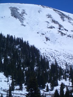 Talked about how nice it would be out there skiing ourselves. (He's the skier, I'd end up sliding down on my rear if I was lucky.) Then drove on until the nest pretty site caught our eye. It didn't take too long to get to Leadville. We pulled into town just in time for a much needed restroom break. We stopped at the first restaurant we saw, I think it was a Hardees but I'm not completely sure. I do remember that there wasn't much to choose from. Everything in Leadville seemed a little run down. It seemed as if time were passing the town by. It still has the feel of an old western mining town. (Or at least what this eastern-born girl imagines one would feel like.) A short way down the street my husband announced that he didn't think he would live here after all.
Another thing that we both like to do is Whitewater Rafting. We've rafted the Gauley River in West Virginia together once and he's gone a few times on his own. We often sit together and research and plan rafting trips and one of our favorite places to dream of rafting is the Arkansas River. Before we started our road trip Ron had found that quite a few of the Colorado Whitewater Rafting companies had headquarters in Buena Vista, CO. Leadville is only 42 minutes from Buena Vista... there was no way we could get that close and not head down there! So we continued our meanderings through Colorado down state route 24 past the ivy league mountains. I was struck by how much the scenery changed on the way down there. Buena Vista's valley is much more desert-like than the area we had just come from. There was red rock all over the place and it was much warmer than back in Idaho Springs. When we got close to the town we found several rafting companies. Both of us were itching to take a trip down the river. If we could have found a reliable babysitter on short notice we'd have been on the next raft! Instead, we had to settle on a view of the river from the shore. While we stood there watching a couple of rafts passed into a nice set of rapids in front of us. We just stood there wishing we were out there with them. I think we could have stayed all day watching them, but the kids were ready to move on.
We wanted to get on with our trip without too much backtracking, so instead of going north back through Leadville we decided to try route 82 to get back to the highway. I was a bit worried to be taking a low priority state road, especially considering our previous track record with the roads through the Colorado high lands. We decided to take our chances though and we made it through ok. This road goes through San Isabel and Gunnison National Forests and skirts the edge of the Hunter Fryingpan Wilderness. There are several opportunities for outdoor recreation along the way. There are a couple of scary sections on this road though. The first ones we encountered were between Buena Vista and Aspen. A couple of times this road goes down to one lane because of large rock overhangs on the side of the mountain. The edge is very steep in most places and when it goes to one lane, most of the time you can't see what is coming toward you. I have no idea if the road is very busy usually, but luckily for us it wasn't that day. Once again, I sat there clutching those oh-sh** handles! It seems like a long section of road between Buena Vista and Aspen, and it's a relatively slow going, but there is beautiful scenery! At the top of Independence Pass, all of us felt a little breathless.
We took a little detour off I-70 to avoid the tunnel and head over Loveland Pass. Then we got back on the interstate for a few minutes and exited on route 91. We just spent the time looking out the windows and talking about what we expected Leadville to be like. We stopped for pictures here and there. Caught some skiers leaving fresh tracks in the snow.
.jpg) Talked about how nice it would be out there skiing ourselves. (He's the skier, I'd end up sliding down on my rear if I was lucky.) Then drove on until the nest pretty site caught our eye. It didn't take too long to get to Leadville. We pulled into town just in time for a much needed restroom break. We stopped at the first restaurant we saw, I think it was a Hardees but I'm not completely sure. I do remember that there wasn't much to choose from. Everything in Leadville seemed a little run down. It seemed as if time were passing the town by. It still has the feel of an old western mining town. (Or at least what this eastern-born girl imagines one would feel like.) A short way down the street my husband announced that he didn't think he would live here after all.
Talked about how nice it would be out there skiing ourselves. (He's the skier, I'd end up sliding down on my rear if I was lucky.) Then drove on until the nest pretty site caught our eye. It didn't take too long to get to Leadville. We pulled into town just in time for a much needed restroom break. We stopped at the first restaurant we saw, I think it was a Hardees but I'm not completely sure. I do remember that there wasn't much to choose from. Everything in Leadville seemed a little run down. It seemed as if time were passing the town by. It still has the feel of an old western mining town. (Or at least what this eastern-born girl imagines one would feel like.) A short way down the street my husband announced that he didn't think he would live here after all.Another thing that we both like to do is Whitewater Rafting. We've rafted the Gauley River in West Virginia together once and he's gone a few times on his own. We often sit together and research and plan rafting trips and one of our favorite places to dream of rafting is the Arkansas River. Before we started our road trip Ron had found that quite a few of the Colorado Whitewater Rafting companies had headquarters in Buena Vista, CO. Leadville is only 42 minutes from Buena Vista... there was no way we could get that close and not head down there! So we continued our meanderings through Colorado down state route 24 past the ivy league mountains. I was struck by how much the scenery changed on the way down there. Buena Vista's valley is much more desert-like than the area we had just come from. There was red rock all over the place and it was much warmer than back in Idaho Springs. When we got close to the town we found several rafting companies. Both of us were itching to take a trip down the river. If we could have found a reliable babysitter on short notice we'd have been on the next raft! Instead, we had to settle on a view of the river from the shore. While we stood there watching a couple of rafts passed into a nice set of rapids in front of us.
.jpg) We just stood there wishing we were out there with them. I think we could have stayed all day watching them, but the kids were ready to move on.
We just stood there wishing we were out there with them. I think we could have stayed all day watching them, but the kids were ready to move on.We wanted to get on with our trip without too much backtracking, so instead of going north back through Leadville we decided to try route 82 to get back to the highway. I was a bit worried to be taking a low priority state road, especially considering our previous track record with the roads through the Colorado high lands. We decided to take our chances though and we made it through ok. This road goes through San Isabel and Gunnison National Forests and skirts the edge of the Hunter Fryingpan Wilderness. There are several opportunities for outdoor recreation along the way. There are a couple of scary sections on this road though. The first ones we encountered were between Buena Vista and Aspen. A couple of times this road goes down to one lane because of large rock overhangs on the side of the mountain. The edge is very steep in most places and when it goes to one lane, most of the time you can't see what is coming toward you. I have no idea if the road is very busy usually, but luckily for us it wasn't that day. Once again, I sat there clutching those oh-sh** handles!
.jpg) It seems like a long section of road between Buena Vista and Aspen, and it's a relatively slow going, but there is beautiful scenery! At the top of Independence Pass, all of us felt a little breathless.
It seems like a long section of road between Buena Vista and Aspen, and it's a relatively slow going, but there is beautiful scenery! At the top of Independence Pass, all of us felt a little breathless.
posted by VA girl at 8:32 PM
![]()
0 Comments:
Post a Comment
<< Home